Back in the autumn of 2009 when I was a woman of independent means I spent ten days walking around London via the Capital Ring. The Capital Ring is one seven strategic walking routes promoted by the Mayor of London and the local authorities. The routes are well signed, with leaflets freely available from Walk London and accessible via public transport. Ideal for unemployed Londoners! The Ring is 78 miles long and encircles London within a 4-10 mile radius from Charing Cross.
So if you want to take a trip around London's highways and byways, green lanes, bridleways, footpaths, towpaths, rivers banks, docklands, parks, country parks, recreation grounds, golf courses, cemetaries and sewers, commons, estates ducal and regal, click here.
Sunday, 11 December 2011
The Capital Ring
The Saffron Trail - Part 2
Hockley to Battlesbridge The next section of the Saffron Trail meanders through Hockley Woods, up over a small hill with excellent views of the Crouch estuary and turns north on farm tracks towards the riverside. The route then heads west along the sea wall towards Battlesbridge. Sadly the last half mile is along a busy pavement-less road. I have walked most of the route on a previous trip to the area on my way around the Essex coast. The weather was much more wintry than of late, but with the occasional burst of sunshine accompanied by a chilly wind. In 1838 a medicinal spring was discovered in Hockley and the pump room was built in 1842. It might not be impressive as pump rooms goes but this building must have made quite an impression when new. Sadly Hockley did not become the Bath of the East.
 Navigating your way through woods is not easy when the paths are covered with leaves so you need to pay close attention to the instructions in Hockley Woods, which were spot on. There are some fine views across the Crouch estuary from the top of a little hill and I enjoyed picking out landmarks from previous walks. You reach the sea wall at the recreation ground in Hullbridge. I watched a curiously mismatched game of football where a team of very small boys took on a team of very large boys. The next couple of miles along the sea wall were rather chilly. The river was rather quiet with only a few yachts to rival the swans (Hullbridge has a lot of swans).
The end point is Battlesbridge, the antiques mecca of Essex. I climbed to the top of the old mill (not for the faint-hearted) to enjoy some splendid views in the cafe, despite the howling wind. After enjoying a tuna sandwich I strolled off to the nearby station in good time for the train home.
8.5 miles 4 hours
Route details
Click here to see more photos
Sunday, 20 November 2011
The Saffron Trail - Part 1
Southend on Sea to Hockley The Saffron Trail, a route devised by Essex Ramblers, runs across the county for 72 miles from Pier Hill in Southend to St Mary's Church in Saffron Walden. I've chosen this route for my winter walking as it's closer to home than the Essex Way. I got off to a glorious start this Saturday, with sunshine from dawn to dusk. It was so warm I nearly had a Rossi's ice cream for breakfast. Setting off from Pier Hill, the Trail heads westwards along the cliff top to Westcliff (wonder how they thought up that name), then along the promenade to Old Leigh. I'd walked this way in 2010 on my way around the coast. From Leigh, the Trail heads back up the cliffs via the Belton Hills nature reserve. There are fine views up and down the Thames Estuary. Having climbed up the hill, the route went back down again and into Hadleigh Castle Country park. The castle was a favorite home of Edward III and subject of a painting by Constable. Alongside the country park is Hadleigh Farm, the site of the Olympic mountain bike course. Most people will not associate Essex with mountains, but having walked up the hill I found it quite steep. I'm looking forward seeing the event next year. I had lunch (tuna sandwich) alongside the replica iron age roundhouse and enjoyed a sunny rest stop before tackling the second half of the walk.
 The route between Hadleigh and Hockley consisted of several areas of open space, Hadleigh Great Wood, Edwards Hall Park and Hockley Woods, linked by the street walking through the suburbs of Southend. On the whole it was quite pleasant walking particularly the last few miles. The Saffron Trail is not a waymarked route so you rely on the accuracy of the description to avoid getting lost. Mostly the instructions were clear and concise, however at Edwards Hall Park, they went a bit awry. I was invited to head west towards a communication mast, when in it should have been east! Also, a mast might not be visible in poor weather. On the way to Hockley there were some very fine views across the Crouch valley with wonderful Canewden church clearly visible. At the end of the walk I enjoyed an ice cream before heading off the station to miss the train home.
14 miles 6.5 hours
Route details
Click here to see more photos
Sunday, 13 November 2011
Fog, mist or low cloud....
White Notley to Coggeshall 6½ miles
 The weather was decidedly gloomy for the next leg of the walk and increasingly misty the deeper into Essex I travelled. It was cool but not really cold when I got off the train at White Notley. Note to self: when travelling to this station be at the back of the train. I was in the front carriage and I swear it took me five minutes to walk the length of the platform to the exit. The end of the train wasn’t even visible due to the mist. This leg to Coggeshall included the usual footpaths and bridleways as well as two short stretches alongside busy roads. The John Ray Walk shares this part of the Essex Way, established to commemorate the life of a natural historian and Essex man of the seventeenth century.
 By Fambridge Hall, I spotted a couple of pigs enjoying their mudbath, however one of them ruined my shot by getting up. Twenty minutes after leaving the station I found myself back there again, just in time to see the train on its way to Liverpool Street! The mist/fog/ low cloud prevented any views at all on the way to Cressing, where I stopped for some refreshment at the church. I passed the time of day with the man who had come to repair the roof. (Please sign this petition re metal theft). Near Cressing but not on the EW route are Cressing Temple Barns. The Wheat Barn,brick-built, and the Barley Barn, weather-boarded, were built by the Knights Templar in the thirteenth century. Attractions include a walled garden and a tea shop.
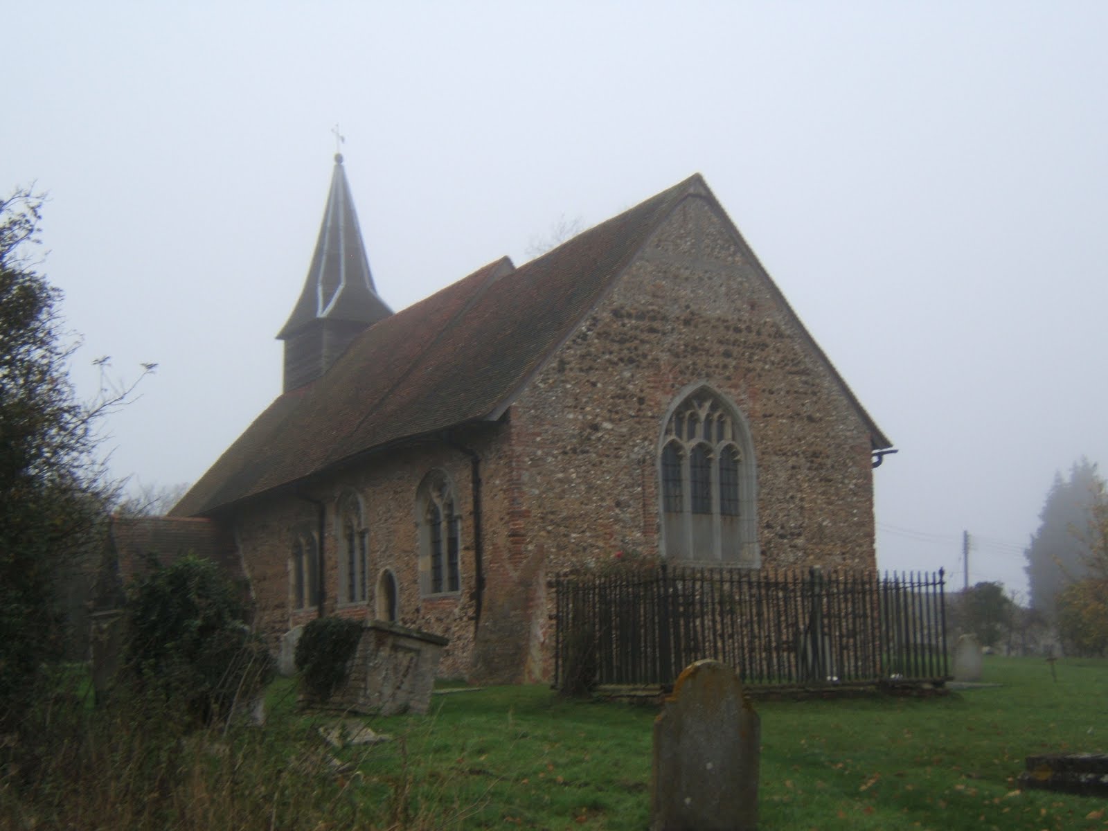 Next rest stop was Bradwell Church, another typical low church with a small broach spire. This one also had some medieval wall painting but was firmly locked. The route between Cressing and Bradwell was shrouded in mist and I managed to lose the Way again, just briefly by not paying close attention to waymarks. I don’t think this section is the most scenic though, passing an active gravel pit and a tip. From Bradwell , the Way follows the Blackwater valley for a couple of miles but the river was masked by trees.
 Arriving at the Grange Barn in Coggeshall, I decided to call it day and catch the bus back to Braintree. Coggeshall is a village full of in interesting architecture, best saved for a brighter day. The number 70 was nearly ten minutes late and I arrived at the bus station with one minute to catch the train. I missed the train by four minutes and was marooned in Braintree for an hour. Time for a late lunch (ham sandwich, banana and orange juice from Sainsbury) before heading home. Coggeshall marks the halfway point along the Essex Way and I intend to resume the walk next spring when the days are longer.
Some Essex Way facts
Progress along the route 41 miles. Total miles walked 53.5 miles.
Click here to see more photos.
I Don't Care What The Weatherman Says....
Great Waltham to White Notley 11 miles
 Despite a dire weather forecast I set off at dawn to return to Great Waltham for the longest leg yet, to White Notley. Fortunately my magic umbrella managed to repel the predicted heavy rain. I got off the bus in GW to be greeted with blue skies and weak sunshine, another perfect day for walking. The village has some interesting architecture including this lovely old Tudor house.
 The first part of the walk was through the grounds of Langleys, a grade 1 listed pile of the Queen Anne period. There was a pet cemetery at the end of the drive and an ornamental bridge over a water feature. Once out of the grounds, the Essex Way heads north and then east through several hamlets and villages on a variety of footpaths, bridleways and quiet lanes, with thankfully, only one muddy field to cross.
 The first rest stop was at the church in Little Leighs, where I had to take refuge in the porch from the light rain. I spotted a pheasant showing off in the churchyard. I mislaid the Essex Way for a bit while crossing over the A131, not helped by the fact that new road wasn’t marked on my old map. However whilest off route, I did spot this strange sculpture from the bridge, variously described as orange ladybirds or giant beetles. It could be a bit off-putting if you catch sight of them while driving towards Braintree.
 Following the valley of the River Ter, I had to deal with ten stiles in a mile and half stretch through various fields and pastures inhabited by horses, individually and in herds. After all that climbing, I was ready for another sit down at Great Leighs church. This church has a lovely Norman round tower on which some Victorian ‘improver’ has stuck a wooden spire. It looks like a witch's hat. Round tower churches are found only in East Anglia and this is one of only six in Essex. Round tower churches have their own society!
 I passed the only pub on route a little before opening time but was deterred from waiting by a stern muddy boot warning. So instead I had a rather meagre snack (fruit, dried fruit and a Tracker bar) at the bus stop at Flack’s Green, Terling. Terling has one of the few smock windmills in Essex but I managed to miss it. The ford through the mighty river Ter was quite pretty. The weather started to change in the afternoon, clouds thickened up and it grew cooler and darker.
 Last rest stop of the day was Fairstead church, which contains Roman brickwork and a little broach spire so typical of Essex churches. It also has some very old wall paintings, but I didn’t venture inside as my boots were rather muddy. The last couple of miles were completed at a goodly lick to ensure I didn’t miss the hourly train at White Notley. The effort was wasted as the train was delayed (by a car striking a bridge). Despite dire warning and leaden skies, I managed to get six hours of walking without getting wet. That magic umbrella really does work.
Some Essex Way facts
Progress along the route 34.6miles. Total miles walked 47.5 miles.
14 stiles on this leg
Click here to see more photos.
Sunday, 30 October 2011
Doe A Deer, A Female Deer.....
Pepper's Green to Great Waltham 8½ miles
 The fourth leg of the Essex Way took me in arc north west of Chelmsford from Pepper's Green to Great Waltham. The weather was once again fine and sunny but the scenery much more autumnal than last week. I had to persuade a rather sceptical bus driver that the 59 to Harlow really did stop where I said it did. As you can see there's not a lot there. Of Salt's Green on the opposite side of the A1060 there was no sign. Most of the day was spent on bridleways, byways and grassy footpaths with just one muddy field to cross.
 Spotting this deer was the highlight of the day. Deer must have very good hearing as Bambi took off when I pressed the focus button. I think it's a fallow deer but I'm not sure. It was a good day for wildlife as I also spotted a fox later in the day. The day's route took in three villages, Good Easter, Pleshey and Great Waltham. They have an unusual firework night in Good Easter, you bring your own fireworks. I hope no one invites Mario Balotelli. However it's a village without a pub, so I pressed on to Pleshey.
 On the way to Pleshey I passed the twenty mile mark, which is a quarter of the way along. Pleshey was once a very important place in Essex. The motte and bailey castle was home to various Earls of Essex before passing to Thomas of Woodstock, Duke of Gloucester. He got bumped of by Richard II and the castle fell into decay. Next time you watch Shakespeare's Richard II listen out for the name check in Act 1, Scene II. The whole village is still enclosed by the earthworks and ditches. What is left of the castle is privately owned but there is a lovely little park by the moat for everyone to enjoy.
 Lunch was taken at the Leather Bottle, (tuna bagette and orange juice and lemonade, £6.49). Pleshey has two pubs and a big Victorian church with a rather cute turret. There are plenty of footpaths so it's not a bad place to visit. It's only a couple of miles to the bus stop in Great Waltham following the course of Walthambury brook. The bus was on time, I saw it whizz along the main road when I still had about 300 metres to go. Sadly the next one was late but there was a seat in the bus stop. I've now gone a quarter of the distance in cloudless conditions. Brilliant!.
Some Essex Way facts
Progress along the route 24 miles. Total miles walked 33.5 miles.
Click here to see more photos.
Sunday, 23 October 2011
A Wander from Ongar
Ongar to Pepper's Green 8 miles
 Taking advantage of the fantastic October weather, I travelled a further eight miles along the Essex way from Ongar to the hamlet of Pepper's Green via Willingale, split into two circular walks. The route was again very green with only a few roads to cross. For two miles north of Ongar, the Essex Way followed the River Roding, which flows into the Thames at Barking Creek. There was also a long section on byways and green lanes which was rather remote; I met one careful motor cyclist, two riders and three other people in just over ninety minutes walking.
 Most people remember Ongar as former end of the Central Line and it does have a museum at the old station. Something I found out through my handy Essex Way guide was the connection with the Titanic. The local Catholic priest was on his way to the United States to conduct his brother's wedding and sadly was lost after volunteering to stay on board. There is a memorial window in the tiny church just of the High Street. There are one or two interesting old buildings , a pretty church and remains of a motte and bailey castle.
 The five miles to Willingale were very pleasant walking along the riverbank or across open fields. It should have been peaceful but for the noise of clay pigeon shooting in a nearby wood. The most memorable building for me was this wonderful thatched caravan. Willingale is unusual as two parish churches share the same churchyard. St Christopher's Willingale Doe, to the north, is the larger, St Andrew's Willingale Spain is the elder. St Andrews was used as a chapel for US air crew during World War 2, when there was a large airfield nearby.
 I returned to Ongar via a long straight bridleway which ran across the old airfield. Apparently it was built using rubble from bombed out buildings of the East End and there are still piles of hard core lying around. The perimeter roads were also still intact and I spotted several cyclists using them. Unbelievably, this was a proposed site for London's third airport.
After Willingale is the hamlet of Shellow Bowells, my favorite Essex place name. It sound positively Dickensian. Then for three miles, it was a pleasant plod to the hamlet of Pepper's Green.
Some Essex Way Facts.
Progress along the route 15¾ miles. Total distance walked 25¼ miles.
Click here to see more photos.
Sunday, 16 October 2011
The only WAY is Essex!
 After tramping around the coast and borders of Essex, I thought it was time to tackle the Essex Way, the premier long distance route in my beloved home county. It runs from Epping Station to Harwich in the far north east 82 miles away. I've already walked the beginning part about three times previously as long ago as 2006, accompanied by the faithful hound, Noddy, and the last part on my coastal walk in 2010. Armed with official guide, (kindly provided by Jason of the Public Rights of Way team, and from which I will plagiarise shamelessly for the blog), I set off on the first leg in a blaze of autumnal sunshine following the poppy signs.
Epping to Ongar 7½ miles
 The first part of the walk involves walking downhill for about half a mile and then uphill for the next two on what is the highest part of the whole route, to Gernon Bushes, a part of Epping Forest. Once across the M11, the route follows a bridleway through the remains of Ongar Park wood and then along a ridge with fine views to the south of places very close to home, Havering Ridge and further afield to Canary Wharf. It was here on a previous walk I spotted a herd of deer. Next stop is the village of Toot Hill and the Green Man Pub where I had lunch (tuna sandwich and orange juice and lemonade, if anyone is interested).
 Between Toot Hill and Greensted the views are less open, following footpaths through paddocks and past large houses, one with an annoying alarm ringing. I was dreading one section which goes through four or five paddocks in quick succession. But the stiles had been replaced by springy metal gates and the horses were absent. Just before Greensted Church, the path actually runs through the yard in front of a converted barn, but I opted to walk around.
 St Andrews Church is the highlight of the day. Possibly the oldest wooden church in the world, it has a Crusader's grave by the front porch and a Leper's squint in the rear wall, from where the afflicted could observe the service and a pretty white tower and broach spire very common in south Essex. It's just a mile through the grounds of Greensted Hall and fields to the finishing point in Ongar where I'd left Archie, for a bun and a cup of tea.
 My impressions of the first leg; it's a very green walk only crossing five roads (or six, if you include the M11), well signposted throughout (apparently our county flower is the poppy) and only four stiles and one very uninterested horse. However in the bright sunshine I managed to miss a sign and had to suffer the indignity of being given directions by other walkers! The paths around Epping are well used and I met a whole peleton of mountain bikers on a green lane near Stewards Green. I experienced a certain amount of walk rage after nearly getting creamed on a fairly narrow bit. No bells, very few thank-yous and an inability to share. You've been warned!
A great first day.
Click here to see more photos.
Tuesday, 22 March 2011
EB5 Lee Valley
 From Sewardstone the walk turns north and for next 40 miles or so the border is delineated by water, firstly the Lee Navigation and then the Stort Navigation. The river Lea is the traditional western border of Essex, separating us from Middlesex. The lower reaches have been lost to Greater London but that still leaves 20 miles of riverside walking to Dobbs Weir, where to Lea heads off into Hertfordshire. The Lea Valley Walk covers all 58 miles of the River Lea from Leagrave near Luton to Limehouse Basin on the Thames. The naturally flowing bit is called the Lea, the canalised bit is known as the Lee. The Lee Valley Regional Park stretches from 26 miles from Ware in Hertfordshire to the Thames. It provides watery leisure space for Londoners, nature reserves for wildlife and the home for white water canoing for the 2012 Olympics.
 Waltham Abbey, as the name suggests, once had an Abbey, famous for being the last resting place of King Harold, possibly. His grave was behind the high alter, but as much of the abbey church and buildings disappeared in the Reformation, now he's marooned in the Abbey Gardens. The gardens are now a public park and there are plenty of information boards around to explain what remains of the monastery buildings. Waltham Abbey has some nice old half timbered buildings, a tiny museum with a fabulous piece of wood panelling on loan from the V & A and a rather old-fashioned tea shop where I had lunch.
The Lee Valley Park has a couple of campsites and I took advantage of the one on the Essex side of the river at Sewardstone. I rather think took advantage of me, charging £17.50 a night in the depths of November. I wasn't very impressed with the facilities; only one toilet block open; one cubicle out of action; showers that had no clothes pegs or stools. The best thing you can say about the site is that it was convenient for the walks I wanted to do. I expect they'll make a mint during the Olympics. I won't be going back.
 Walk 8 This was a short circular walk from the campsite to link up with the previous walk. The weather was sunny but hazy obscuring the view from the top of Gilwell Hill across the Lee Valley and King George's Resevoir. The Scouts have an big campsite with an amazing obstacle course, somehow I managed to resist sliding down the big tubes. It would have been embarassing if I got stuck. From Sewardstone I took a footpath on the very edge of Essex back to the campsite. A muddy 2.5 miles
Walk 9 In complete constrast to the previous walk, the weather was dull, dark, dank and dismal. The route to Waltham Abbey hugged the Essex border by the Lee and crossed the Greenwich Meridian at some point. Surprisingly rural, I got to Waltham Abbey having only crossed one road. It was all a bit boggy until reaching Gunpowder Park, which is laid out with all-weather paths to encourage cyclists. This is a relatively new park, having previously been a Royal Ordnance munitions testing site, which has left some odd humps behind. The highlight for me was, obviously, Cob Hill, which I'm sure has a very nice view when it's not raining. I arrived at Waltham Abbey in time for lunch. A slightly damp 5.5 miles
 Walk 10 Suitable replete, I set off for a circular walk around the Lee Valley Country Park leaving the Abbey gardens via a handy underpass. The country park has been created from old gravel pits, so is very popular with bird watchers. I'm not sure that November is the best time for a visit though. I headed towards Fishers Green via Cornmill meadows and returned along the canal towpath which fortunately, is on the Essex bank at this point. A few hardy souls were aboard moored boats but no one was taking their cruiser for a spin. I arrived back at Waltham Abbey in the gathering gloom to catch the hourly bus back to camp. Too late I realised I was at the wrong stop and made vague effort at running. To my amazement the bus driver took pity on me and picked me up. I was most effusive in my thanks. A watery 6.5 miles
  Walk 11 Three months later and it's back to Fishers Green. This time I employed the services of a local guide a nature expert, Frankie. I should have listened to her as we headed off towards Nazeing as we had to retrace our steps as a promised footpath failed to materialise. We followed cycle route no 1 over Clayton Hill, in and around Nazeing and eventually rejoined the Lee towpath just south of Dobbs Weir. There was a good view from the hill over the Lee valley, if you avoid looking at Harlow. Very enjoyable 6 miles
Completed distance 80 miles
CLICK ON PICTURE TO OPEN ALBUM
 |
| EB5 Lee Valley |
Sunday, 20 March 2011
The Far East
 This month's camping trip took me to Lowestoft in Suffolk. Why, you ask? To complete the compass rose of Britain by visiting the most easterly point, Lowestoft Ness. From the campsite at Kessingland I could see the bright lights of Lowestoft and Gulliver, Britains's tallest wind tower. I was lucky enough to secure the last beach side pitch, (the campsite has only been open an hour and half!). As it was rather cold, I retired early but set the alarm so I could see the dawn rise from bedroom window. I woke up to find the van encased in ice so I had to watch the very chilly dawn from outside instead. It was a pretty sunrise and I would be one of the first people in Britain to see it.
 It about six miles from the campsite to Lowestoft and I was able to walk all the way along the coast. It was an absolutely glorious day, fully twelve hours of unbroken sunshine, the winds were light but chilly. Ness Point is hidden away behind the port, off Gas Works Roads towards the north of the town. It's a rather forlorn spot, marked by Euroscope, a direction finder giving distances to the capitals of Europe. The Hague is 110 miles away and London 106 miles. It also marked the other cardinal points of Britain; south, Lizard Point, 352 miles; north, Dunnet Head, 472 miles; west, Ardnamurchan Point, 451 miles.
I was able to watch the moon rise from my sitting room, and what a fantastic site it was too. Huge and pink, it seemed to fill the sky and moonlight on the water was brilliant. Apparently it was a super moon.
CLICK ON THE PICTURE BELOW TO OPEN THE ALBUM

Saturday, 12 March 2011
EB4 Epping Forest
 Epping Forest has been the playground of Londoners since 1878 when the Corporation of London became Conservators of Epping Forest and the general public were granted legal access for the first time. The Corporation acted to prevent greedy landowners from enclosing what remained of the Forest, (it's hard to visualise the City as champions of the comman man). Epping had been one of the many Royal Forests and covered much of Essex. The Forest was made up of a mixture of woodland and grazing, the trees provided cover for the deer and the locals grazed their cows and made off with firewood, pretty much as they do today. Epping is full of large, pollarded oaks, many centuries old. Pollarding prevented deer from eating the new growth. Sadly I didn't pass one on my walks but they are very impressive.
 What remains of Epping forms a crescent shape extending from the Lower Forest just south of Harlow to Wanstead Flats, less than 6 miles from the heart of London. The main part of the Forest lies between Chingford and Epping with Loughton at the centre. Centenary Walk extends from 12 miles from Manor House to Epping, linking all the various parcels of land. It's a very enjoyable walk but comes with two particular hazards; firstly, the waymarking is poor and secondly, you have to cross some very busy roads. The highest point is Ambresbury Banks near Epping but Pole Hill, the highest point in Waltham Forest, has the best view, overlooking Central London, the Olympic Stadium, Millenium Dome and the aerials of Crystal Palace.
 The undoubted jewel in the crown is the Queen Elizabeth's Hunting Lodge, just south of the Essex border at Chingford. Actually built for Henry VIII, it provided a grandstand for monarch and guests to watch and/or participate in the hunt by loosing of their arrows at the deer, a latterday shooting party. It's free to visit and open most weekends. The other popular place is High Beach, so called from the sandy nature of the soil. It's the location of the Visitor Centre, several pubs, an ice cream van and hordes of picnickers on sunny days. Sadly, the Epping Forest Festival, a celebration of all things foresty, has been discontinued due to budget cuts. Shame!!
 Walk 6 took me around the border with Redbridge, from Cabin Hill in Hainault Forest to the mighty river Ching on Whitehall Plain. It started and ended in trees but otherwise, you couldn't see the forest for the houses. This is the point where the Green Belt disappears and London and Essex merge. I'm pretty sure that the entrance to Grange Hill Station is in Essex but the platforms are in Redbridge. There was a very fine view from Grange Hill east towards the QEII bridge, Tilbury power station and Havering Ridge, giving me a chance to see how far I've come.
 Then followed a long road section through Chigwell to Luxborough Lane to cross the M11. Just pass the Spurs training ground was a small bit of greenery along the Roding valley before more pavement pounding to Buckhurst Hill. I stopped for a snack at a local bakers but wouldn't recommend it. The last part of the route went through Lord's Bushes, past pretty St John's pond and ended on Whitehall Plain. The bridge over the Ching marks the point were Essex, Redbridge and Waltham Forest meet. I can only assume the Ching was a much mightier river if it required a ford because you wouldn't need to be Jade Johnson to jump over it now. The weather was mild and sunny, the trees wore their autumn colours, a pleasant 10 miles.
 Walk 7 was a short hop taking me through Epping Forest to the River Lea or Lee, the traditional western boundary of Essex. Starting just over the border at the Queen Elizabeth Hunting Lodge, I followed the River Ching to Connaught water and then through the Bury Wood to Sewardstonebury. There isn't much waymarking in the Forest and it's quite easy to get lost so I had to use Brimble's Guide to Epping Forest, with large scale maps, to navigate. Once across Bury Road, I followed Woodman's Ride to Yardley Hill and down the other side to Sewardstone. It was another crisp, sunny autumnal day. However this is not the place to come if you want a quiet walk. You'll meet mountains bikers, horse riders, gangs of joggers, packs of dog walkers, rabbles of ramblers, screaming kids and blokes flying model aeroplanes, to name just a few. A pleasant, if crowded, 3 miles.
60 miles completed
CLICK ON THE PICTURE BELOW TO OPEN ALBUM

Tuesday, 1 March 2011
London Loopy
Coulsdon South Station to Banstead Downs
A short and boring section through the London Borough of Sutton, the main highlight was Oaks Park.
A short and boring section through the London Borough of Sutton, the main highlight was Oaks Park.
 A Stalking Horse
To find out more (about the walk and my encounter with the horse) click here.
Sunday, 20 February 2011
First Camping Trip of 2011
After a break over the winter Archie and I hit the road for our first jaunt of 2011. We took a spin around the M25 to the Caravan Club site at Denham, about 10 minutes from junction 17. The site is really a glorified car park with very big spaces and clean toilets. I expected a bit of aircraft noise, being not too far from Heathrow. I hadn't bargained for helicopters landing next door at Denham Airfield in the middle of the night!

Denham is in South Buckinghamshire, the birthplace of the Paralympics, but right next door to Hertfordshire, the County of Opportunity, to do what? There are plenty of posh houses about, Cilla Black lives in Denham Green, but surprise, surprise, I didn't meet her. Denham village was once the home of Sir John Mills who lived in this very nice house.
There was plenty of footpaths about and I purchased a local guide which I promptly lost without ever reading. I managed a couple of circular walks from the site to the Grand Union Canal on Friday and Sunday but Saturday was a washout. Once the rain stopped I strolled around the adjacent nature reserve. I drove off and left the stool behind, the sixth stool I either lost or driven over!
Subscribe to:
Posts (Atom)
About Me

- Jill 'n' Noddy
- fat, fifty+, fond of books, lover of lists, keen camper, mad about maps, alien from the planet Alphabetica