Showing posts with label Essex Way. Show all posts

Sunday, 13 November 2011

Fog, mist or low cloud....


White Notley to Coggeshall 6½ miles


The weather was decidedly gloomy for the next leg of the walk and increasingly misty the deeper into Essex I travelled. It was cool but not really cold when I got off the train at White Notley. Note to self: when travelling to this station be at the back of the train. I was in the front carriage and I swear it took me five minutes to walk the length of the platform to the exit. The end of the train wasn’t even visible due to the mist. This leg to Coggeshall included the usual footpaths and bridleways as well as two short stretches alongside busy roads. The John Ray Walk shares this part of the Essex Way, established to commemorate the life of a natural historian and Essex man of the seventeenth century.


By Fambridge Hall, I spotted a couple of pigs enjoying their mudbath, however one of them ruined my shot by getting up. Twenty minutes after leaving the station I found myself back there again, just in time to see the train on its way to Liverpool Street! The mist/fog/ low cloud prevented any views at all on the way to Cressing, where I stopped for some refreshment at the church. I passed the time of day with the man who had come to repair the roof. (Please sign this petition re metal theft). Near Cressing but not on the EW route are Cressing Temple Barns. The Wheat Barn,brick-built, and the Barley Barn, weather-boarded, were built by the Knights Templar in the thirteenth century. Attractions include a walled garden and a tea shop.


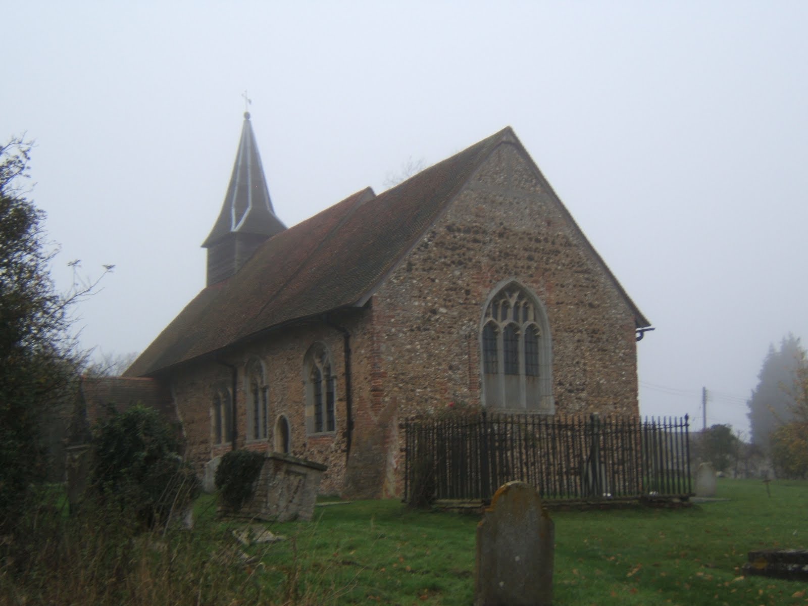
Next rest stop was Bradwell Church, another typical low church with a small broach spire. This one also had some medieval wall painting but was firmly locked. The route between Cressing and Bradwell was shrouded in mist and I managed to lose the Way again, just briefly by not paying close attention to waymarks. I don’t think this section is the most scenic though, passing an active gravel pit and a tip. From Bradwell , the Way follows the Blackwater valley for a couple of miles but the river was masked by trees.


Arriving at the Grange Barn in Coggeshall, I decided to call it day and catch the bus back to Braintree. Coggeshall is a village full of in interesting architecture, best saved for a brighter day. The number 70 was nearly ten minutes late and I arrived at the bus station with one minute to catch the train. I missed the train by four minutes and was marooned in Braintree for an hour. Time for a late lunch (ham sandwich, banana and orange juice from Sainsbury) before heading home. Coggeshall marks the halfway point along the Essex Way and I intend to resume the walk next spring when the days are longer.


Some Essex Way facts
Progress along the route 41 miles. Total miles walked 53.5 miles.

Click here to see more photos.

I Don't Care What The Weatherman Says....


Great Waltham to White Notley 11 miles


Despite a dire weather forecast I set off at dawn to return to Great Waltham for the longest leg yet, to White Notley. Fortunately my magic umbrella managed to repel the predicted heavy rain. I got off the bus in GW to be greeted with blue skies and weak sunshine, another perfect day for walking. The village has some interesting architecture including this lovely old Tudor house.


The first part of the walk was through the grounds of Langleys, a grade 1 listed pile of the Queen Anne period. There was a pet cemetery at the end of the drive and an ornamental bridge over a water feature. Once out of the grounds, the Essex Way heads north and then east through several hamlets and villages on a variety of footpaths, bridleways and quiet lanes, with thankfully, only one muddy field to cross.


The first rest stop was at the church in Little Leighs, where I had to take refuge in the porch from the light rain. I spotted a pheasant showing off in the churchyard. I mislaid the Essex Way for a bit while crossing over the A131, not helped by the fact that new road wasn’t marked on my old map. However whilest off route, I did spot this strange sculpture from the bridge, variously described as orange ladybirds or giant beetles. It could be a bit off-putting if you catch sight of them while driving towards Braintree.


Following the valley of the River Ter, I had to deal with ten stiles in a mile and half stretch through various fields and pastures inhabited by horses, individually and in herds. After all that climbing, I was ready for another sit down at Great Leighs church. This church has a lovely Norman round tower on which some Victorian ‘improver’ has stuck a wooden spire. It looks like a witch's hat. Round tower churches are found only in East Anglia and this is one of only six in Essex. Round tower churches have their own society!


I passed the only pub on route a little before opening time but was deterred from waiting by a stern muddy boot warning. So instead I had a rather meagre snack (fruit, dried fruit and a Tracker bar) at the bus stop at Flack’s Green, Terling. Terling has one of the few smock windmills in Essex but I managed to miss it. The ford through the mighty river Ter was quite pretty. The weather started to change in the afternoon, clouds thickened up and it grew cooler and darker.


Last rest stop of the day was Fairstead church, which contains Roman brickwork and a little broach spire so typical of Essex churches. It also has some very old wall paintings, but I didn’t venture inside as my boots were rather muddy. The last couple of miles were completed at a goodly lick to ensure I didn’t miss the hourly train at White Notley. The effort was wasted as the train was delayed (by a car striking a bridge). Despite dire warning and leaden skies, I managed to get six hours of walking without getting wet. That magic umbrella really does work.


Some Essex Way facts

Progress along the route 34.6miles. Total miles walked 47.5 miles.
14 stiles on this leg

Click here to see more photos.


Sunday, 30 October 2011

Doe A Deer, A Female Deer.....


Pepper's Green to Great Waltham 8½ miles


The fourth leg of the Essex Way took me in arc north west of Chelmsford from Pepper's Green to Great Waltham. The weather was once again fine and sunny but the scenery much more autumnal than last week. I had to persuade a rather sceptical bus driver that the 59 to Harlow really did stop where I said it did. As you can see there's not a lot there. Of Salt's Green on the opposite side of the A1060 there was no sign. Most of the day was spent on bridleways, byways and grassy footpaths with just one muddy field to cross.

Spotting this deer was the highlight of the day. Deer must have very good hearing as Bambi took off when I pressed the focus button. I think it's a fallow deer but I'm not sure. It was a good day for wildlife as I also spotted a fox later in the day. The day's route took in three villages, Good Easter, Pleshey and Great Waltham. They have an unusual firework night in Good Easter, you bring your own fireworks. I hope no one invites Mario Balotelli. However it's a village without a pub, so I pressed on to Pleshey.

On the way to Pleshey I passed the twenty mile mark, which is a quarter of the way along. Pleshey was once a very important place in Essex. The motte and bailey castle was home to various Earls of Essex before passing to Thomas of Woodstock, Duke of Gloucester. He got bumped of by Richard II and the castle fell into decay. Next time you watch Shakespeare's Richard II listen out for the name check in Act 1, Scene II. The whole village is still enclosed by the earthworks and ditches. What is left of the castle is privately owned but there is a lovely little park by the moat for everyone to enjoy.

Lunch was taken at the Leather Bottle, (tuna bagette and orange juice and lemonade, £6.49). Pleshey has two pubs and a big Victorian church with a rather cute turret. There are plenty of footpaths so it's not a bad place to visit. It's only a couple of miles to the bus stop in Great Waltham following the course of Walthambury brook. The bus was on time, I saw it whizz along the main road when I still had about 300 metres to go. Sadly the next one was late but there was a seat in the bus stop. I've now gone a quarter of the distance in cloudless conditions. Brilliant!.

Some Essex Way facts

Progress along the route 24 miles. Total miles walked 33.5 miles.

Click here to see more photos.


Sunday, 23 October 2011

A Wander from Ongar


Ongar to Pepper's Green 8 miles

Taking advantage of the fantastic October weather, I travelled a further eight miles along the Essex way from Ongar to the hamlet of Pepper's Green via Willingale, split into two circular walks. The route was again very green with only a few roads to cross. For two miles north of Ongar, the Essex Way followed the River Roding, which flows into the Thames at Barking Creek. There was also a long section on byways and green lanes which was rather remote; I met one careful motor cyclist, two riders and three other people in just over ninety minutes walking.


Most people remember Ongar as former end of the Central Line and it does have a museum at the old station. Something I found out through my handy Essex Way guide was the connection with the Titanic. The local Catholic priest was on his way to the United States to conduct his brother's wedding and sadly was lost after volunteering to stay on board. There is a memorial window in the tiny church just of the High Street. There are one or two interesting old buildings , a pretty church and remains of a motte and bailey castle.


The five miles to Willingale were very pleasant walking along the riverbank or across open fields. It should have been peaceful but for the noise of clay pigeon shooting in a nearby wood. The most memorable building for me was this wonderful thatched caravan. Willingale is unusual as two parish churches share the same churchyard. St Christopher's Willingale Doe, to the north, is the larger, St Andrew's Willingale Spain is the elder. St Andrews was used as a chapel for US air crew during World War 2, when there was a large airfield nearby.


I returned to Ongar via a long straight bridleway which ran across the old airfield. Apparently it was built using rubble from bombed out buildings of the East End and there are still piles of hard core lying around. The perimeter roads were also still intact and I spotted several cyclists using them. Unbelievably, this was a proposed site for London's third airport.


After Willingale is the hamlet of Shellow Bowells, my favorite Essex place name. It sound positively Dickensian. Then for three miles, it was a pleasant plod to the hamlet of Pepper's Green.


Some Essex Way Facts.
Progress along the route 15¾ miles. Total distance walked 25¼ miles.


Click here to see more photos.

Sunday, 16 October 2011

The only WAY is Essex!


After tramping around the coast and borders of Essex, I thought it was time to tackle the Essex Way, the premier long distance route in my beloved home county. It runs from Epping Station to Harwich in the far north east 82 miles away. I've already walked the beginning part about three times previously as long ago as 2006, accompanied by the faithful hound, Noddy, and the last part on my coastal walk in 2010. Armed with official guide, (kindly provided by Jason of the Public Rights of Way team, and from which I will plagiarise shamelessly for the blog), I set off on the first leg in a blaze of autumnal sunshine following the poppy signs.


Epping to Ongar 7½ miles

The first part of the walk involves walking downhill for about half a mile and then uphill for the next two on what is the highest part of the whole route, to Gernon Bushes, a part of Epping Forest. Once across the M11, the route follows a bridleway through the remains of Ongar Park wood and then along a ridge with fine views to the south of places very close to home, Havering Ridge and further afield to Canary Wharf. It was here on a previous walk I spotted a herd of deer. Next stop is the village of Toot Hill and the Green Man Pub where I had lunch (tuna sandwich and orange juice and lemonade, if anyone is interested).

Between Toot Hill and Greensted the views are less open, following footpaths through paddocks and past large houses, one with an annoying alarm ringing. I was dreading one section which goes through four or five paddocks in quick succession. But the stiles had been replaced by springy metal gates and the horses were absent. Just before Greensted Church, the path actually runs through the yard in front of a converted barn, but I opted to walk around.

St Andrews Church is the highlight of the day. Possibly the oldest wooden church in the world, it has a Crusader's grave by the front porch and a Leper's squint in the rear wall, from where the afflicted could observe the service and a pretty white tower and broach spire very common in south Essex. It's just a mile through the grounds of Greensted Hall and fields to the finishing point in Ongar where I'd left Archie, for a bun and a cup of tea.


My impressions of the first leg; it's a very green walk only crossing five roads (or six, if you include the M11), well signposted throughout (apparently our county flower is the poppy) and only four stiles and one very uninterested horse. However in the bright sunshine I managed to miss a sign and had to suffer the indignity of being given directions by other walkers! The paths around Epping are well used and I met a whole peleton of mountain bikers on a green lane near Stewards Green. I experienced a certain amount of walk rage after nearly getting creamed on a fairly narrow bit. No bells, very few thank-yous and an inability to share. You've been warned!

A great first day.

Click here to see more photos.