Tuesday 30 March 2010

Walking the Essex Coast - Leigh to Shoeburyness

Between Leigh Station and the MOD site at Shoeburyness lies seven and half miles of unbroken access to the coast, with Southend-on-Sea, the largest town in Essex, right in the middle. As a family, the Cobbs preferred to spend the day on the beach at Chalkwall or Westcliff and then walk into Southend at the end of the day. I always hoped we would go to the Kursaal, but in the Sixties it was a den of inequity (according to my parents), so we ended up at Peter Pan’s Playground instead (now morphed into Never Never Land). Southend is the only known place where I’ve eaten a boiled egg (1959) and the Cobbs still enjoy a day out there once in a while but without the walking.

I decided to start in Shoeburyness as I'd never been there before. I nearly never left the station as I got locked in the ladies toilets by an over-zealous cleaner. It was a very fine morning, warm sun, a soft breeze and for once I felt a bit overdressed. Shoeburyness is a military town of long standing. There was a fine Royal Artillery Garrison, complete with chapel, school, hospital, a wonderful horseshoe shaped parade ground, barrack rooms and fine buildings for the Officers. Their purpose was to guard the mouth of the Thames. The Garrison closed in 1976 and is now a bijou housing development, a mixture of renovated military buildings and new build. The Chapel is the developer’s HQ. Sign of the times.

The MOD still have a strong presence in Shoeburyness with firing ranges along the coast. About a mile of coastline at Pig’s Bay is completely inaccessible. I started my walk from the East beach of Shoeburyness, home to the Thames boom, a WW2 defensive installation that almost as long as Southend Pier. There were plenty of other gun emplacements and blockhouses along this stretch of the coast. East Beach is very pleasant, a large strip of grass next to a sand and shingle beach. It was extremely popular with dog walkers but people were less friendly here than on other parts of the coastal walk. Not a friendly place for van owners either! (Another bloody height restriction)

Walking around Shoebury Ness (headland) was the most enjoyable part of the day, the sun was warm, no traffic noise, waves lapping at the sea wall and no view of Southend. East Beach is separated from Shoebury Common by the Garrison site and old firing ranges. The ranges have become Gunners Park and a nature reserve, and a cycle path follows alongside the sea wall. It must be some sort of concessionary route as the way out was firmly barred at Shoebury common and I had climb over the sea wall and walk around the fence. This part of the coast is very good for sea birds and I was treated to marvellous flying display from a flock of small plump birds believed to be Knots. The flock changed colour from grey to white as they changed direction.

After Shoebury Common the coast and the A13 are very close together all the way to Southend. There were plenty of hardy souls out walking or getting their beach huts ready for the glorious summer we are all surely going to enjoy. As I reached the town centre the lovely weather faded somewhat, but not enough to frighten off the punters from seaside delights of Essex’s premier seaside resort.

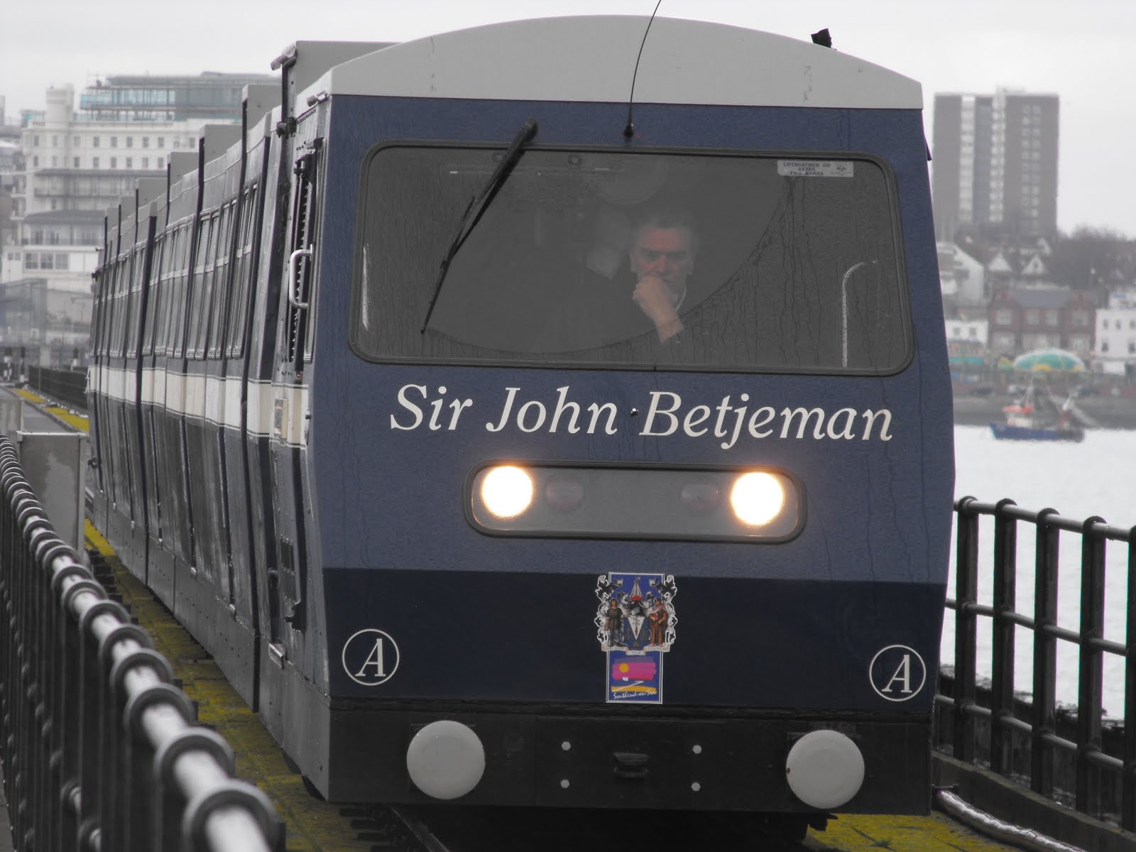
Southend Pier, the most famous thing about Southend, is over a mile long, so I decided to take the train. I emerged from the ten minute ride to find the end of pier in a squall. Everyone had taken shelter from the wind and rain in the café so there was no room for me. The sun deck was empty and views were hazy to say the least. I walked back along the pier and as I neared the land the weather improved, the sun coming out as I returned to shore.

The next part of the walk was along the cliffs to Westcliff. The cliffs are about a hundred feet high so the views over the Thames estuary are impressive if visibility is good. Clifftown is rather genteel, not a word normally associated with Southend, all white brick, large windows and wrought iron verandas. Clifftown is a Victorian era development with an obligatory statue of said Queen pointing in a rather rude manner. The Royal Terrace is Georgian, the Royal in question being Princess Caroline, the wife of the Prince Regent, a woman with a very bad reputation, who would probably feel quite at home if she visited Southend today.

The cliffs were also laid out with pleasure gardens, dating back to Georgian times and have recently been renovated courtesy of the Lottery. Prittlewell Square is a fine example of a Victorian public space with a wrought iron gateway and pond. The Cliff Lift, a funicular railway linking the cliff top with the beach, has also been restored to its former Victorian glory but wasn't open. I seem to remember that they looked quite pretty at night with fairy lights.

On reaching the Cliffs Pavillion, which does not feature in Pevsner, I returned to the seafront. I paused for a Rossi’s ice cream, another Southend speciality and continued along past the beaches of Westcliff and Chalkwall. The tide was out by now and a few people were out digging bait or walking the dog, and one very hardy couple were having a paddle!

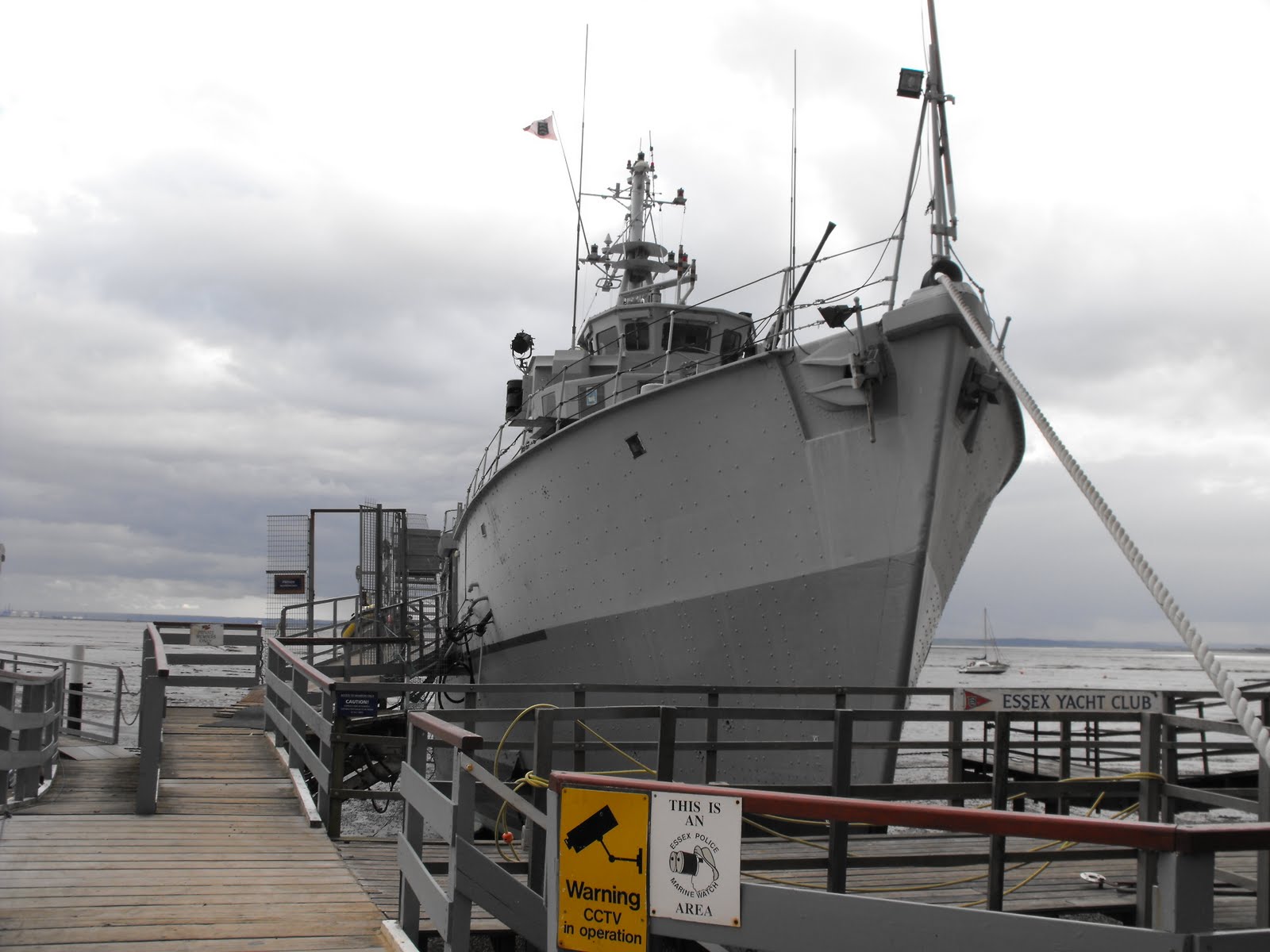
At Chalkwall Station the railway runs right next to the coast as the cliffs are quite close to the river at this point. The nature of the river and coast also changes being more industrial, with fishing boats aplenty. The large military vessel easily spotted from the train is the Wilton, a former minesweeper and now a club for yachting types. Wilton was a bit of a bargain for them as she is made of plastic and won't rust.

The London, Tilbury & Southend railway opened in 1854 and completely split the village of Leigh from it parish church on the hill. This has helped old Leigh retain its village atmosphere, with a cobbled main street and clapperboard buildings. The Old Smithy has been restored into a heritage centre and museum. Fish is still caught and sold by Leigh fisherman from the booths and shacks that line the road back to the station. The train ride back took an hour to cover the ground it has taken me three months to cover on foot. This walk marks the end of the ‘easy’ bit of the Essex coast, the Thames estuary.

To see more pictures of Southend and the rest of the Thames estuary coastline click here.

Wednesday 24 March 2010

Pointless topping - Slough


If ever there was an example of pointless topping, it was my trip to Slough. The high(est) point of Slough is a spot height in the middle of a busy road along the northern border, with no obvious hill or slope. General consensus of opinion among fellow toppers is that the dog poo bin is the symbolic top, (something Slough shares with Southend) as trying to find the actual top would probably get you killed. Almost all of the walk to and from the top took place in Buckinghamshire along some narrow but rather busy lanes and some litter strewn bridleways and footpaths. I left Archie at Burnham Beeches which is a very pleasant open space a couple of miles north of Slough. The last time I visited you could drive through it but it now appears to be a car-free zone.

Traditionally Slough was part of Buckinghamshire until 1974 when it was dumped on poor old Berkshire. In 1998 it became a unitary authority when poor old Berkshire was dismantled, which is how it qualifies for a top. Slough is so devoid of any tourist attractions that it was impossible to find any on its own Council website. Its greatest claim to fame seems to be the association with Ricky Gervais and the Office. I find it hard to believe that it only 42nd on the list of least favorite towns in the Idler Book of Crap Towns. Extensive research for this blog reveals that Slough means swamp. Says it all!

Wednesday 17 March 2010

Walking the Essex Coast - Two Tree Island

Two Tree Island, like Canvey was reclaimed from the sea. It lies between Leigh and Canvey, separated by Leigh Creek to the north and Hadleigh Ray to the south. It is a mile and half long and half a mile wide and was used mainly by sheep until the twentieth century, when, like so many other bits of the Essex coast line, it was turned into a rubbish dump. After the tip closed in the seventies, the island became a nature reserve.

The western half is in Castle Point district and forms part of Hadleigh Castle Country Park. East of the road is in Southend and is part of the Leigh National Nature Reserve. The one road leads to southern edge where there is a public slipway and the only car park on the island that doesn’t have a height barrier. You can park right on the edge of the salt marsh and watch the boats heading up and down the Thames. Can you spot Archie?

The western half is mainly open grassland with a good metalled path all around. It has fine views towards Canvey and Hadleigh Castle. It is very popular with birdwatchers with two hides at the western end; one overlooks Hadleigh Ray and is a good place to spot wading birds at low tide and the other is by a pool popular with the avocets that breed on the island. The hides were very popular and a good way to make yourself unpopular is to let door slam. It is possible to cross to the mainland at low tide by scrambling across the creek. This part of the island is home to a model flying club so you have to watch out for small, low flying aircraft that make as much noise as the real thing.

At the western end it is possible to see two of the ‘county top’ of Essex. Westley Heights, the highest point of Thurrock, is large whaleback shaped hill about eight miles away. It’s a sizeable hill by Essex standards, rising out of the marshes and topped (as any good top usually is) by a large aerial mast. The highest point of Southend is just a mile to the north at the top of Belton Hills. They are about a hundred foot shorter but still make a steep climb (for Essex). The view from the top is very impressive stretching from the mouth of the Thames to the top of Canary Wharf on a clear day.

The eastern half is more covered with lots of scrub and bushes. There were some inland bird hides by a pond and a feeding area with a useful identification chart. I think I spotted a Great Tit. There is a very pleasant walk along the old sea wall by the salt marsh and mud flats. The whole area is very popular with wildfowl and waders, particularly Brent geese who feed on the eelgrass. The basketwork is made of hemlock and helps stabilise the marsh.

Two Tree Island is a very pleasant spot for spotting, birds, boats or aircraft or for just taking a stroll by the sea side.

To see more pictures of Two Tree Island and the rest of the Thames estuary coastline click here.

Friday 12 March 2010

Walking the Essex Coast - Canvey Island

Apparently we have the Dutch to thank for Canvey Island. They turned up in the seventeenth century, built dykes and reclaimed the land from the sea, although most of it lies beneath sea level. They liked the place so much that they settled there and left behind two pretty circular cottages, one of which is a museum. The Dutch influence is still strong in Canvey and can be seen in road names like Harlaam Road or Heeswijk Avenue. Most people know of Canvey Island because of the disastrous floods in 1953 that claimed 58 lives. Since that time sea defences have been strengthened and Canvey is circled by sixteen miles of sea wall, all of which is accessible to the public. Famous Canvey natives include Olympic decathlete Dean Macey and some bloke from Dr Feelgood.

Canvey Island has everything that the Thames estuary coastline has to offer good and bad; salt marsh and river marsh, farmland, industry and industrial wasteland, boatyards, beaches, birdlife and long stretches of riverside walking. It wasn’t that difficult to escape the madding crowd on an island barely five miles wide and three miles deep, and home to nearly 40,000 people. Until the Victorian era Canvey was home mainly to sheep. It suddenly became fashionable as a sea side resort, and given the size of the two caravan parks, it still is popular today. However, flooding is still a problem!

Not up to the challenge of walking around the sea wall in one go, this walk was done over two greyish days, with the old shower and sunny interval. The main difference was the wind which was absent of day one making it feel quite mild. I started from Benfleet, which has a sizeable car park (no height barrier and free at weekends). Benfleet Church has finely carved wooden porch and there is an old looking pub in the High Street called the Hoy and Helmet. This is something to do with ships not our famous cycling Olympian. It’s a short walk from Benfleet to the bridge onto Canvey and the sea wall and I started on the western side walking around the island in an anti-clockwise direction.

The western side of Canvey is the least built up part and there are fine views across the marshes to Bowers Marsh and of the surrounding hill top villages of South Benfleet and Pitsea. However the first few miles alongside East Haven Creek are within earshot of the A130, so not that peaceful. The sea wall here is a grassy mound and has been churned up by hooved animals. It was a testament to the drying wind that it wasn’t a morass but merely bumpy. The RSPB will be opening a new reserve on West Canvey this year but sadly the car park had a height restriction so I won’t be visiting.

After a few miles East Haven Creek joins Vange Creek at the moveable flood barriers to form the much substantial Holehaven Creek. There was a fine view east to Tilbury Power station, Fobbing Church and marshes and the oil refineries at Coryton on the other bank. At this point the sea wall becomes much more substantial too, with concrete walls and a firm metalled track. This part was popular with horse riders and cyclists as well as other walkers and there was actually some activity on the river. Some piece of machinery in the oil refinery makes the noise of a very large drum making the very regular booming noise that I heard when walking in East Tilbury.

After crossing under a disused pipeline at Canvey Wick, it was possible to get onto the water’s edge as you approach the Thames. On the western bank is Shellhaven Point and Holehaven Point is on the eastern bank. I stopped for refreshment at the Lobster Smack pub, mentioned in Great Expectations, hidden behind the sea wall. Next door are old Coastguard cottages, some horrible new development, and acres of oil storages units. The southern coast of Canvey stretches for about four miles alongside the Thames estuary which is over a mile wide at this point. The Kent coastline is dominated by the power station on the Isle of Grain.

Travelling west to east, you pass the oil storage depots, Thorney Bay Caravan Park (looks a bit like a WW2 POW camp), Thorney Bay, an inlet with a sandy beach and then the sea front promenade of Canvey which looks as if it has seen better days. The coast line is shingly with the odd bit of sand. The Labworth Café built in the 1930’s was designed by Ove Arup who went on to build the Sydney Opera House. It is possible to walk on either side of the sea wall as a couple of the floodgates have been opened to allow access.

Just past the Yacht Club on the eastern end of Canvey and you can walk out onto the salt marsh and follow a ‘footpath’ to Canvey Point, the most easterly point. I remember taking Noddy here a few years ago and he trod in something that turned his paws black and was extremely difficult to remove. Not knowing the tide tables, I turned back at the warning barrier. There is a fine view east to Southend Pier and the river looks huge as it meets the North Sea. It was also the first point on my journey that smelt like the seaside, a distinctly salty tang in the air.

The eastern end of Canvey is where the boating types hang out with boats of every description packed along Smallgains Creek. Next to the boatyards is Canvey Heights Country Park, reclaimed from the old town tip. A small but perfectly formed little hill gives you a splendid 360° panorama over Canvey, the Thames Estuary and Southend. This was where I stopped for lunch to admire said view, before turning west along the northern edge of the island. Next to the Heights is another big mobile home park, slightly more upmarket than Thorney Bay. This part of Canvey was the area worst affected by the floods of 1953.

Despite the closeness of the houses I thought this was a particularly pleasant stretch of walking, with marshes then a narrow stretch of water separating Canvey from Benfleet Marshes and good views of Hadleigh Castle. I spotted a curlew wading in the mudflats and barely passed a soul. The northern sea wall runs alongside the local golf course so I suppose it could be a bit dangerous if someone shanks a ball.

I enjoyed this walk very much; it was very peaceful, the scenery was always changing and there was plenty of variety and a few surprises, and with the exception of a couple of stiles, it wasn’t too hard.

To see more pictures of the beautiful Essex coast click here.

Tuesday 9 March 2010

Walking the Essex Coast - Benfleet to Leigh

From Benfleet, you can follow the coastline uninterrupted for ten miles to Shoebury Ness. I walked the first four miles to Leigh over a weekend which explains the difference in the photos. On Saturday I walked the eastern part of the route with my mate Frankie. We did a circular walk from Hadleigh Castle Country Park on a cold day with some intermittant sunshine. I walked the whole distance on the following day in glorious late afternoon sunshine finishing in the glow of dusk. Another difference was the number of people present. HCCP was awash with walkers, twitchers, dog walkers, cyclists and joggers on Saturday, including one runner who impressively hurdled a stile! Late on Sunday afternoon I only saw a few hardy souls braving the very chilly wind.

The footpath to Leigh runs along the sea wall. Benfleet Creek separates Canvey Island from mainland Essex. It was extremely raw in the east wind with little shelter. At Benfleet there was a sizable marina with quite a few houseboats of various sizes. This was first large collection of boats I'd seen since Grays and Tilbury. Once past the moorings, you enter the country park and it's three miles to the next road. Benfleet Creek starts to widen and it's possible to see the big boats on the Thames proper to south of Canvey.

Hadleigh Castle Country Park is one of the largest in Essex and is spread out over Benfleet Downs and Benfleet Marshes and is split in two by the C2C railway. There are several waymarked walks as this map shows. The Downs are surprisingly steep for Essex but they do afford great views along the Thames Estuary. We could see as far as Tilbury power station eastwards, but on a clear day it is possible to see Canary Wharf. The views from Hadleigh Castle, just outside the park are equally good towards Southend and its famous pier and south to Kent and the Isle of Grain.

Hadleigh Castle is, according to my mate Pevsner, the most important later medieval castle in the county. I'm not sure that says a great deal as Essex is not a county overloaded with castles. It was a ruin by the sixteenth century and later used by the revenue men to spy on all that smuggling down on the marshes. Not a lot remains today apart from a bit of curtain wall and the remnants of four circular towers. The largest (south east) tower was painted by Constable in 1829.

Frankie and I set off for our circular walk from the car park (£2 all day, no height barrier and toilets) and headed downhill, over the railway line and the marshes to join the sea wall at the half way point between Benfleet and Leigh. Despite the drying wind, everywhere was very muddy or waterlogged, with large areas of standing water guarenteed whenever you needed to cross at a stile. The sea wall was much better underfoot and we made good time into Leigh. Across the creek are Canvey and Two Tree Island, which are next on the itinerary.

The eastern part of Two Tree Island is part of HCCP and it is possible to cross the narrow creek at low tide to visit the bird hides. The whole area is very good for birdwatching, and according to Frankie, we saw great spotted woodpecker, green woodpecker, redshank, curlew, black-tailed godwit, avocet and lapwing. The avocets and the brent geese provided some good aerial displays and was able to snap the curlew in Leigh marshes a bit further along. (It's to the right and slighty above the gull).

We were treated to a slightly different aerial display by three model aeroplanes fans reliving the Battle of Britain. At first I wasn't sure if they were small planes or just very far away as the noise was quite realistic. It did pall after a bit as this is a very peaceful part of the coastline. C2C trains are now very quiet and barely noticable. Just before reaching Leigh, Frankie and I had a pit stop at the golf driving range cafe for a well earned cuppa.

Refreshed, we set off over Leigh marshes for the last half mile to Leigh Station. From here I got the first sighting of Southend Pier about five miles away. Once past Leigh Station we turned back westward towards Hadleigh Castle, where we heaved ourselves over an extraordinarily high stile when there was a perfectly good gate we could have used. The weather improved in the afternoon with plenty of sunshine, when we stopped for yet more refreshment.

The last part of the walk was all uphill back to the car park and pretty tiring too. Two hundred feet climbs are rare in Essex. We were relaxing in the van enjoying yet another well-earned cuppa when the glass hob cover on the cooker exploded. Apparently you aren't supposed to put it down with the gas still on! Don't try this at home as it took me two hours to clean up the glass!

To see more pictures of the beautiful Essex coast click here.

Monday 8 March 2010

Walking the Essex Coast - Pitsea to Benfleet

The walk from Pitsea to Benfleet was the last link in the route back to the Essex coast. It was a gloriously sunny afternoon with clear blue skies and a bitingly cold wind direct from Siberia, an excellent day for walking. The old tower of Pitsea church is now a mast for the Orange telephone network. Orange have tidied up the churchyard and added a seat so you can enjoy the splendid view from the Mount. To the west were the oil refineries at Coryton, Fobbing Church and flooded marshes of Vange. To east, Bowers marshes, Canvey Island and the water tower on the ridge at South Benfleet.

The footpath to Benfleet follows the railway line east. Once past the housing estate, the footpath crosses a couple fields sandwiched between the A13 and the railway. The ground underfoot ran the gamut from hard to soft to waterlogged, so it's obviously going to take some time for the ground to dry out. It didn't seem to bother the ponies living in the field, who fortunately didn't seemto be interested in me.

After a mile and a half you come to the delightful little church of St Margaret's, Bowers Gifford. Completely isolated, it is dwarfed by the electricity pylon behind. According to Pevsner it has an unusual single buttress on the tower and a broach spire, which is quite common in south Essex. It was closed but the churchyard was in good repair and the seat at the sunny west end was most welcome.

A little while after the church, the footpath crosses the railway line onto Bowers Marsh, another large area of emptiness just a few miles from Basildon. There are a couple of farms, lots of ditches and another hugh landfill site. In 2011, this will become RSPB Bowers, a wetland nature reserve, with hides, walks, lagoons and reed beds, and hopefully a car park without a height restriction. The footpath to Benfleet station was clearly marked on the map and with a helpful finger post pointing in the wrong direction. It was a lot harder to spot on the ground and may well have disappeared under water in places. It was no surprise that I had the whole place to myself, it felt more like the Steppes of Russia than Essex.

A combination of map reading, GPS and a pretty obvious target (A130 main road to Canvey) got me back on track. The road marks the boundary between Basildon and Castle Point and is also the point where you pick up the coast proper along the northern bank of East Holehaven Creek. Houseboats were tied up along the banks and one of the occupants gave me a cheery wave. I followed the rather indistinct path to Benfleet station.

At South Benfleet the river cliffs come very close to coast. The railway is on one side of the road and the river is on the other. I sat on bench opposite the station and took in the view. Across the creek, Canvey Island was basking in the golden glow of the late afternoon sunshine and the oil refineries seemed much nearer than before such is the curve of the coastline.

It all looked very, very flat.

To see more pictures of the beautiful Essex coast, click here.

Wednesday 3 March 2010

Wat Tyler Country Park, Basildon

Wat Tyler, as many of you may know, was the leader of the Peasants Revolt in 1381. What you may not know is the Peasants Revolt started here in Essex, which means we invented poll tax riots. The country park is on a spit of land between Timbermans Creek and Pitseahall Fleet, about 3 miles from the centre of Basildon.

The park has been created on the site of a former explosive factory were nitro-glycerine was manufactured. The site is littered with large blast barriers formed from earth. There was a naval depot here in WW2. The new visitors centre has a very nice exhibition that produces some very loud bangs. The whole park is getting refurbished at the moment so there are lots of tractors everywhere.

The country park is a bit of mish-mash of things; there are several old vernacular buildings in a rather sorry state of repair dotted about the site; there is a minature railways which chugs around the site on high days and holidays; the National Motorboat Museum which nows appears to be closed indefinitely; Vange Wharf and boatyards with lots of the little motor boats; a RSPB visitor centre and bird hides dotted along the creeks. Unfortunately the day I visited it was half-term and it was full of revolting children.

London Loopy

West Wickham Common to Hamsey Green

Section four of the London Loop wandered from Bromley, through Croydon to the very borders of Surrey. It was a woody, muddy, hilly walk with a fantastic view. It was very nearly my last walk...


To find out more click here