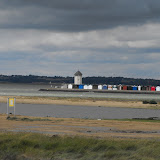
Thurrock, where this walk starts, is best known for the Lakeside Shopping Centre, the QEII Bridge and Tilbury Docks. It had a brief moment of fame as the 'funeral' in the film 4 Weddings etc, otherwise it's mainly an extention of urban, industrial London. Not a very attractive place for either walking or visiting, you might think. Well think again! Tilbury Fort (pictured) was the place where Queen Elizabeth I made her famous speech stirring up the troops before the Spanish Armada in 1558. There are several attractive villages just a few minutes from Lakeside like Horndon-on-the-Hill and Orsett and according to Thurrock Council , there are over 100 miles of footpaths and bridleways and they have a very nice map to prove it.
 To start with, there is about 20 miles of fine riverside walking along the Thames Estuary. Belhus Woods was once a deer park landscaped by Capability Brown. The country house has long since been demolished and the Long Pond was cut in half by the M25 in 1979. The country park is owned by Thurrock, run by Essex CC but most of the park is actually in Havering. Belhus is just one of several wooded areas in the west of the Borough that are part of the Thames Chase forest project.
 The Mar Dyke, a tiny tributary of the Thames, flows through Thurrock, joining the big river at Purfleet. The Mardyke way is bridleway which runs for about seven miles through farmland, with excellent views of Langdon Hill to the east. At 377ft it the highest point of Thurrock, but most of the good views are from the bit that's in Basildon. So I had plenty of footpaths and countryside to work with in devising a walk from Essex border by the Thames to West Horndon in neighbouring Brentwood.
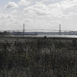
 I split the distance into two walks; walk 1 from Rainham Station to Ockendon Station and walk 2 from Ockendon Station to West Horndon Station. I was blessed with some very good weather on both days. The first view of Essex was brilliant, the Queen Elizabeth II bridge bathed in sunshine with a fleet of little yachts racing up the Thames. The highlight of walk 1 was a guided tour around St Michael's Church in Aveley.There was a beautiful Flemish style painting and very old brass of Sir Ralph of Knevyynton, hidden away under a carpet and a piece of cardboard.
Walk 1 took me along the Thames from Rainham, with a brief stop for refreshments at Rainham RSPB. I aimed to link Purfleet and Aveley using footpath 145, which once was a nice country stroll but is now bisected by two railway lines, the old A13 and the new A13. Having failed to find a safe crossing over a six lane highway, I had to make my way to Aveley by road, discovering on the way that Aveley is on top of hill. From Aveley, I crossed Belhus park, getting slightly lost on the golf course, around the country park (another refreshment stop) and over the M25 to a little bit more woodland. Hidden away in Oak Wood is an icehouse and the overgrown remains of the Long Pond. Knocking down country houses and turning the estates into country parks for the masses is something of a recurring theme in Essex. Walk 1 finished at Ockendon Station and covered 13 miles.
 Walk 2 should have started at Ockendon station but unfortunately I got on the wrong train and ended up at West Horndon instead. The highlight of this walk was probably me falling down the steps and landing on my backside. The route to Ockendon was almost all footpaths or bridleways. Some of it involved walking across ploughed fields, rather unpleasant after all the recent rain. One footpath seemed to end in a horse paddock forcing me to trespass through a farmyard. I actually met another walker along the Mardyke way. I had to inform him that the Harrow pub where he planned to stop for lunch had recently burned down. At the Ockendon end the footpath went along a driveway which once had avenue of limetrees. Only the stumps remained but you can see what it looked like in 2005 by clicking here.. 8 miles
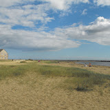
 So there you have it, first section completed, 21 miles walked. Take a look at the photos and you'll probably be surprised how green and pleasant Thurrock is.
Click on the picture to open the album.